Confirming a Suspected Rift Valley
Geologists Show that Seafloor Dynamics Are at Work in Splitting African Continent.
In 2005, a gigantic, 35-mile-long rift broke open the desert ground in Ethiopia. At the time, some geologists believed the rift was the beginning of a new ocean as two parts of the Africa
n continent pulled apart, but the claim was controversial.
Now, scientists from several countries have confirmed that the volcanic processes at work beneath the Ethiopian rift are nearly identical to those at the bottom of the world's oceans, and the rift is indeed likely the beginning of a new sea.

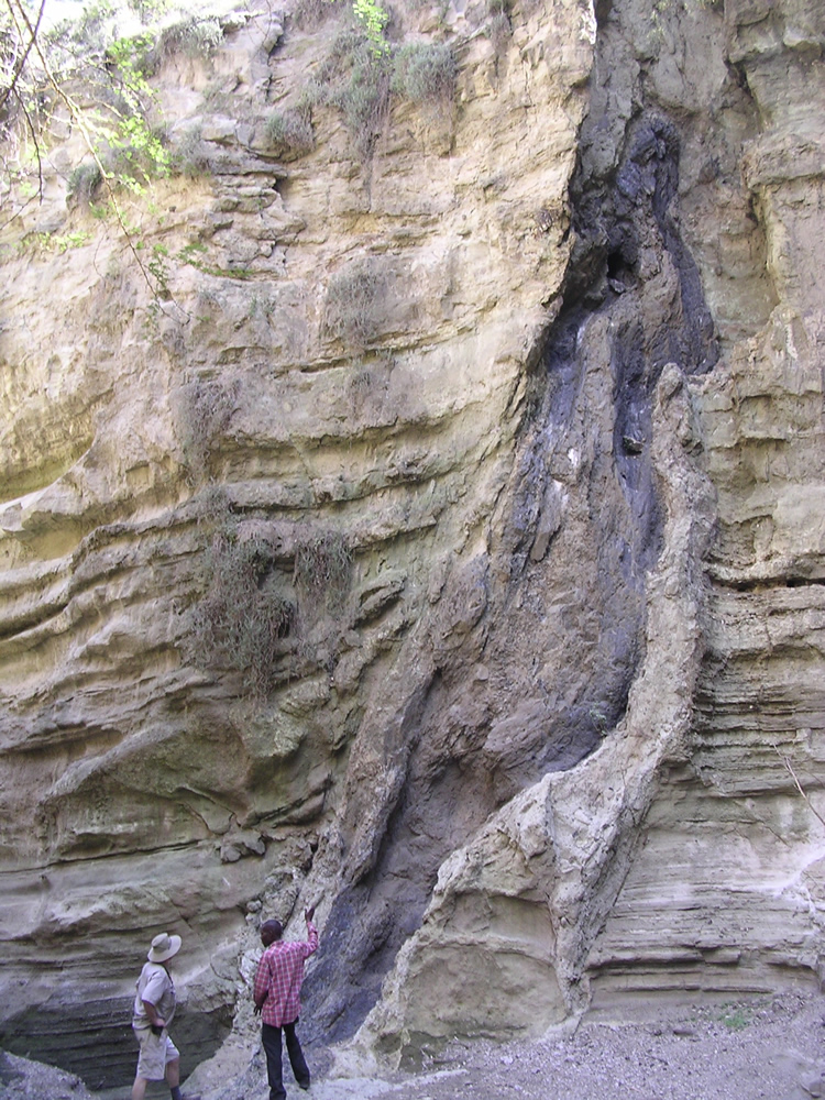
Aerial view of the rift near Afar, Ethiopia.
"Rifting In Concert"
"For the first time they demonstrate that activity on one rift segment can trigger a major episode of magma injection and associated deformation on a neighboring segment. Careful study of the 2005 mega-dike intrusion and its aftermath will continue to provide extraordinary opportunities for learning about continental rifts and mid-ocean ridges."
Is Ethiopia Analogous to Ocean-Ridge Rifting?
"The whole point of this study is to learn whether what is happening in Ethiopia is like what is happening at the bottom of the ocean where it's almost impossible f
or us to go," says Ebinger. "We knew that if we could establish that, then Ethiopia would essentially be a unique and superb ocean-ridge laboratory for us. Because of the unprecedented cross-border collaboration behind this research, we now know that the answer is yes, it is analogous."
Aerial view looking down the rift valley bounded by tall, near-vertical fault scarps
Twenty Feet of Rifting in a Few Days
Atalay Ayele, professor at the Addis Ababa University in Ethiopia, led the investigation, painstakingly gathering seismic data surrounding the 2005 event that led to the giant rift opening more than 20 feet in width in just days. Along with the seismic information from Ethiopia, Ayele combined data from neighboring Eritrea with the help of Ghebrebrhan Ogubazghi, professor at the Eritrea Institute of Technology, and from Yemen with the help of Jamal Sholan of the National Yemen Seismological Observatory Center. The map he drew of when and where earthquakes happened in the region fit tremendously well with the more detailed analyses Ebinger has conducted in more recent years.
Ayele's reconstruction of events showed that the rift did not open in a series of small earthquakes over an extended period of time, but tore open along its entire 35-mile length in just days. A volcano called Dabbahu at the northern end of the rift erupted first, then magma pushed up through the middle of the rift area and began "unzipping" the rift in both directions, says Ebinger.
Since the 2005 event, Ebinger and her colleagues have installed seismometers and measured 12 similar—though dramatically less intense—events.
"We know that seafloor ridges are created by a similar intrusion of magma into a rift, but we never knew that a huge length of the ridge could break open at once like this," says Ebinger. She explains that since the areas where the seafloor is spreading are almost always situated under miles of ocean, it's nearly impossible to monitor more than a small section of the ridge at once so there's no way for geologists to know how much of the ridge may break open and spread at any one time. "Seafloor ridges are made up of sections, each of which can be hundreds of miles long. Because of this study, we now know that each one of those segments can tear open in a just a few days."
Ebinger and her colleagues are continuing to monitor the area in Ethiopia to learn more about how the magma system beneath the rift evolves as the rift continues to grow.
_______________
Fonte: geology.com


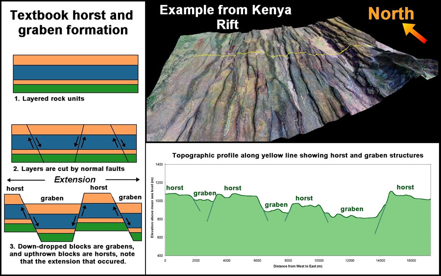
 Figure 3: "Textbook" horst and graben formation (left) compared with actual rift terrain (upper right) and topography (lower right). Notice how the width taken up by the trapezoidal areas undergoing normal faulting and horst and graben formation increases from top to bottom in the left panel. Rifts are considered extensional features (continental plates are pulling apart) and so often display this type of structure. To enlarge (http://geology.com/articles/east-africa-rift/figure3.jpg)
 Figure 4: Triple Junction in the Afar region of Ethiopia. Image shows areas of stretched and oceanic crust as well as areas of exposed flood basalts that preceded rifting. Areas unshaded or covered by flood basalts represent normal continental crust. As the crust is pulled apart you end up with thinned crust with a complex mixture of continental and volcanic rock. Eventually the crust thins to the point where oceanic-type basalts are erupted which is the signal that new ocean crust is being formed. This can be seen in the Gulf of Aden as well as a small sliver within the Red Sea. The original extent of the flood basalts would have been greater, but large areas have been buried within the rift valley by other volcanic eruptions and sediments. To enlarge (http://geology.com/articles/east-africa-rift/figure4.jpg)
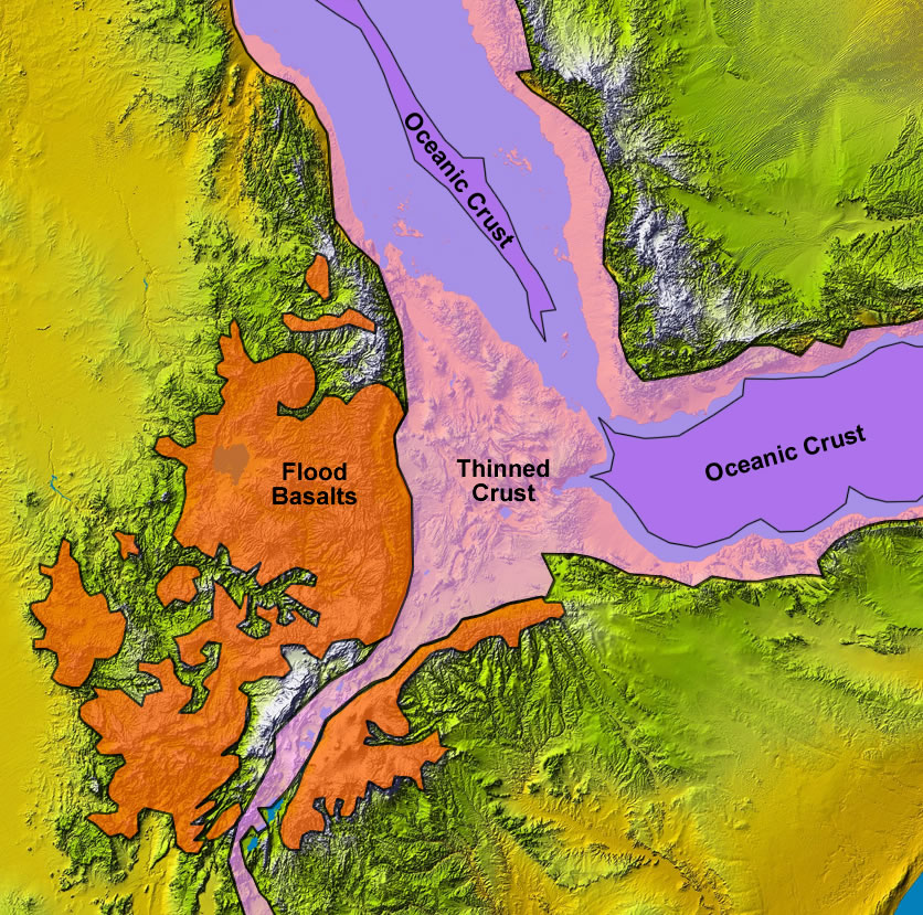
