Mostrar mensagens com a etiqueta English Posts. Mostrar todas as mensagens

14 agosto 2013

Statoil to sponsor "Arctic Race of Norway" cycling event

Statoil has signed an agreement to be the general sponsor of the Arctic Race of Norway cycling event in northern Norway. This will be the largest sporting event ever hosted in Norway, measured in number of television viewers across the world.

Bilde 

Knut-Eirik Dybdal (front) and Ole Skardal are two of the initiators of the Arctic Race of Norway. (Photo: Ivar Hjelvik)

A four-day stage race, the Arctic Race of Norway will feature some of the world's top cyclists and will be set against the backdrop of northern Norway's spectacular landscapes. 

This year's event will be televised to around 100 countries. Statoil has signed a three-year agreement with the race organisers, and during this time period, all three of Norway's northernmost counties will host the race.

Bilde 

Anita Andersen Stenhaug, director Norne-Aasta Hansteen, Statoil's Harstad offices

"Northern Norway is important to Statoil. This is why we want to take part in promoting and developing the region as an attractive location for business development. The Arctic Race of Norway will be one of the most exciting sporting events in the years ahead, and it is only natural for Statoil to contribute," says Anita Andersen Stenhaug, director Norne – Aasta Hansteen at Statoil's offices in Harstad.

Local enthusiasts in the region took the initiative for the bicycle race. For more than 18 months, they have worked with great passion and belief in the concept.

This lead to the Amaury Sports Organisation (ASO) - owners of the Tour de France and the Dakar Rally amongst other events - seeing the race's potential. 

Every year, ASO receives many similar requests to take part in such events, but they thought the Arctic Race of Norway would be a unique opportunity, both in regards to the passion surrounding the event and the fantastic landscapes that northern Norway has to offer.

Bilde 

Communications director Reidar Gjærum

ASO will handle the logistics surrounding the cycling aspect of Arctic Race of Norway.

"Arctic Race is an excellent opportunity to showcase what northern Norway has to offer. At the same time, it can help build Statoil's position in the region. It is important that we strengthen our position and long-term business opportunities," says communications director Reidar Gjærum.

"Cycling is a sport with a major international fan base in markets that are important to the company, such as Europe. Therefore, after close consideration, we decided to contribute to the execution of this event. We must invest in future growth and opportunities, even during times when we cut costs. We're eagerly awaiting the start of the race in August," Gjærum says.

Hopefully, Arctic Race of Norway will inspire even more people to strap on their bike helmets and hit the road, including Statoil employees. Many will get the chance to see the star cyclists up close, while millions will follow the race through the TV broadcasts.
The broadcasts will be televised in prime time during the afternoons and evenings, thanks to the unique light conditions in northern Norway in August.

Statoil will contribute a fixed annual amount of NOK 8 million for each of the years of the agreement.

Knut-Eirik Dybdal, prime initiator and general manager of the Arctic Race of Norway in Harstad, is grateful for Statoil's involvement.

"Without Statoil we would be unable to host the Arctic Race. Not only has Statoil contributed funds through its role as general sponsor, but the company also contributes invaluable expertise in planning and execution," Dybdal says.
___________________________________________________________________________
Retirado de:

29 julho 2013

Hong Kong's International Airport - Building Chek Lap Kok IA

Opened on 6 July 1998, it took six years and US$20 billion to build. According to the Guinness World Records the project is the most expensive airport project ever completed.


Join us, and Discovery Channel, in this project of Extreme Engineering


18 julho 2013

Gold mining...by plants!


Money doesn't grow on trees — but gold just might. An international team of scientists has found a way to grow and harvest gold from crop plants. Called phytomining, this technique of finding gold uses plants to extract particles of the precious metal from soil. 

Some plants have the natural ability to take up through their roots and concentrate metals such as nickel, cadmium and zinc in their leaves and shoots. For years, scientists have explored the use of such plants, dubbed hyperaccumulators, for pollution removal. But there are no known gold hyperaccumulators, because gold doesn't easily dissolve in water so plants have no natural way of taking the particles in through their roots.

"Under certain chemical conditions, gold solubility can be forced," said Chris Anderson, an environmental geochemist and gold phytomining expert at Massey University in New Zealand.

07 junho 2013

Opposition grows to Norway's Arctic oil search

By Gwladys Fouché
 
The seas off the picturesque Lofoten islands could hold 20% of the country's remaining undiscovered oil and gas reserves

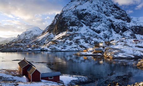
 Bay and mountain at sunset at Tind, one of Lofoten Islands in Norway 
Photograph: Peter Adams/Peter Adams

Perched 200km north of the Arctic Circle, the Lofoten islands in Norway paint a picture-perfect image of serenity. High mountains plunge into the sea, villages of brightly painted wooden houses nestle on the shores of sheltered bays, while fishing boats pull gently on their anchors. But underneath the surface, the Lofoten islands are the latest battleground for the right to exploit the polar region's oil and gas resources, with local fishermen and environmentalists hoping to defeat a multi­billion pound industry.

As Norway's oil reserves in the North Sea are emptying – the country is the world's fifth largest oil exporter – it is now looking to the Arctic north in search of new oil riches. And the Lofoten islands appear promising. Between May and September, Norway's state oil agency will be mapping the seabed outside the archipelago in search of hydrocarbon deposits, as it already did in 2008.

"We expect the area to hold 20% of all remaining undiscovered reserves on the Norwegian continental shelf," explained Odd-Ragnar Lorentsen from the Norwegian Petroleum Directorate (NPD).

This view is shared by the oil companies, which are not currently allowed to explore in the region. "There is a potential for oil and gas off the Lofoten," said Oerjan Birkeland, exploration manager for the Norwegian oil company StatoilHydro. "We would like the region to be opened [for drilling]. We must have the ability to explore."

But not everyone is welcoming a potential oil boom in the region. The fishing industry, which has dominated the economy of the region for the past millennium, fears oil activity could endanger the Barents Sea cod, the largest cod stock in the Atlantic Ocean, which spawns off the coast of Lofoten in February-March and is a highly profitable fisheries.

"I am absolutely against searching for oil and gas in the Lofoten area," said a visibly angry Rolf Arne Jacobsen, a 52-year-old fisherman, in the port of Svolvær. "It would be a catastrophic development that would endanger both the fisheries and nature."

Surveying has already been killing off fish stocks. To map the seabed, scientists shoot out an air pulse at high pressure that rebounds on the seabed, killing any small fish within a 10-metre radius. "The dead fish float on the surface after the surveying ships have done their research," claimed Jacobsen. And it is not known what effects the surveying has on the surviving fish. In some regions, 2008's catches of hake are a tenth of what they were on 2007's – and the fishermen blame the seismic surveys.

The tourism industry is also up in arms, as Lofoten is one of Norway's top tourist destinations, with travellers flocking to admire its flora and fauna. "Lofoten would be a less attractive destination," said Heike Vester, who runs marine safaris from the port of Henningsvær.
Vester is afraid that oil installations, such as offshore platforms, pipelines and other on-land installations would damage the pristine nature and kill her business. "When I tell my customers what's going on, they tell me they don't want to come back," she said.

Environmentalists also have huge concerns for the fragile Arctic environment. "There are even more storms here than in the North Sea, and during the winter there is only daylight for three to four hours per day [making cleaning operations more difficult]," said Maren Esmark, head of conservation at WWF-Norway. "An oil spill would have more dramatic consequences, especially since the areas that are being surveyed are very near the coast."

However, not everyone is opposed to the idea. "We just can't live off tourism and service jobs, we need other types of jobs too," said Brita Malnes, who owns a cornershop in Henningsvær. "If oil and gas mean we could get jobs, then it would be good. But at the same time it should not destroy the nature around here."

Public information meetings for Lofoten's 23,500 inhabitants last year have been tumultuous. "In 30 years of working in the oil industry I have never seen such reactions," said Lorentsen. "At one meeting, a grandmother was in tears because she thought we were going to put her grandson, a fisherman, out of work… People are scared and we should understand that."

Part of Lorentsen's surprise is that this is a country that has grown fabulously wealthy on the oil industry. Thanks to the North Sea's resources, Norway boasts one of the world's largest GDP per capita (about $55,669 or £38,242 in 2008, compared with the UK's $35,070).

But it is precisely the North Sea's declining reserves that are driving the search for oil in the north. Oil production peaked in 2001, and "by 2023, it will have reduced by 50%," said Birkeland. "The way forward is to increase recovery from existing fields and increase exploration."

Already one gas field, Snow White, is being exploited in the Norwegian side of the Barents Sea, with oil companies discovering new fields every year.

StatoilHydro alone has drilled 21 wells and made 14 discoveries. "We made two finds just in 2008," said Birkeland.

Another company, the Italian oil group ENI, is hoping to get the right to exploit the Goliat oil field in the Barents Sea.

Politicians are divided about the way forward. In the cabinet coalition, the Socialist Left party is opposed to oil exploration around Lofoten, while the dominant partner, Labour, is broadly in favour. Similarly, in opposition, the Christian Democrats and the Liberals oppose it while the Conservatives are in favour. Oil exploration in the Lofoten is already set to be one of the top issues of September's general election.

The Norwegian parliament is to decide in 2010 whether to open up the Lofoten to oil exploitation. And in the meantime surveying activities off the coast of the archipelago will continue.
____________________________________________________________________________
Retirado de:
06 junho 2013

Conferência: "Natural Disasters: Understanding the Science and the Risks"

Fig. 1 - Cartaz da conferência: "Natural Disasters: Understanding the Science and the Riscks", na FCUL.


A geóloga de origem portuguesa Isabel Sacramento Grilo, da San Diego State University, da Califórnia,  aceitou fazer uma conferência na FCUL, no próximo dia 12 de Junho, quarta-feira, às 15 horas no Anfiteatro 6.2.53, sobre um tema que lhe é caro na sua actividade recente nos Estados Unidos da América, os desastres naturais como polarizadores do interesse de não cientistas por Ciência:


"Natural Disasters: Understanding the Science and the Risks:
A show case of one of the most popular courses at San Diego State University in California – Natural Disasters. This talk will examine how natural processes and their energy release, involving land, water, sky and space, impact humans, often with tremendous deaths tolls. Who gets affected? Why? Where... Students learn to appreciate Earth’s processes and how we are powerless in the face of this energy release.
This talk provides an overview of how using natural disasters works really well in teaching earth science at the undergraduate level."


A conferencista dedica-se à leccionação de cursos gerais de geologia a estudantes de outras áreas científicas e acompanha a formação de professores de Ciências na Califórnia:


(…) Isabel is a geologistin the Department of Geological Sciences at San Diego State University, in California, where she teaches lower and upper division courses for majors and non-majors, with a focus and expertise in Geosciences Education for science teachers. 
A celebrated educator who brings modern instructional technology to the classroom, she teaches classes like Earth Science, Natural Disasters, and Oceanography. She’s also part of an on-going project aimed at fostering excellence in the preparation of elementary teachers in science with the New Generation Science Standards, to enhance their knowledge, confidence, and excitement about the teaching of science.”


A conferência está orientada para a apresentação dos processos da dinâmica da Terra como uma via para estimular a curiosidade e o interesse em aprender Ciência, um interesse partilhado por todos os professores que ensinam ciências nas escolas, a públicos jovens. A discussão que se pode gerar após, podendo ser conduzida em português, porque a conferencista domina bem a língua portuguesa, é uma oportunidade de partilha de experiências que não deve ser desperdiçada. Compareçam!

08 maio 2013

Analysing the Bingham Canyon mine landslide part 2: the landslide track


The best overview image of the track of the landslide is this one (used with permission courtesy of the Kennecott Utah flickr site).


The first thing to note is that the block that failed does not extend to the floor of the mine – in fact it toes out about half way up the slope.  The landslide has run across the lower slope without inducing any major failure in this area.  So, on the lower slope it is still possible to see the remains of the mining benches, although they have been eroded from the passage of the landslide.


07 maio 2013

USGS Topo Data on the Go


Android and iPhone users can now use their mobile devices as digital topo maps, leveraging USGS maps together with the power of GPS to zoom in on their precise location while hiking, biking, running, or any other activity that benefits from precision navigation. The type of data that are available includes USGS imagery and topographic maps from The National Map, as well as road and contour layers.  

06 maio 2013

The Bingham Canyon Mine Landslide - Part 1


The Bingham Canyon mine landslide of a few weeks ago is an unusual mass movement.  Kennecott Utah have put a set of very high resolution images on their flickr site and have provided permission for me to use them here (with due acknowledgement to them).  I thought it would be interesting to take a little time to examine this landslide in more detail. There is a great deal to discuss here, so I am going to break this down into three posts over the next few days.
So lets start by looking at the site from a Google Earth image.  This is a vast mine – the excavation is 970 m deep for example.


 This image shows the slope that failed before the collapse event.  Note the machinery on the haul road for scale.


copyright Kennecott Utah - used with permission


02 maio 2013

Earthquakes Make Gold Veins in an Instant


Scientists have long known that veins of gold are formed by mineral deposition from hot fluids flowing through cracks deep in Earth’s crust. But a study published today in Nature Geoscience has found that the process can occur almost instantaneously — possibly within a few tenths of a second.

01 maio 2013

Gold - Digging microbe


Forget ancient maps and metal detectors. Those seeking hidden gold might do well to add bacteria to their toolbox. The bacterium Delftia acidovorans secretes a molecule that binds to dissolved gold and turns it into shiny, solid gold, scientists have discovered.

26 março 2013

STRATI 2013, Lisbon - First International Congress on Stratigraphy


It is with pleasure that the Organizing Committee announces the 1st International Congress on Stratigraphy (STRATI 2013), to be held in Lisbon, 1–7 July 2013. The 1st International Congress on Stratigraphy follows the conferences organized by the French Committee of Stratigraphy (STRATI).


After several successes, a clear trend towards internationalization of STRATI that culminated in 2010 in Paris, led the organizers to propose that the next Congress was held in Portugal, within the Department of Earth Sciences and Centre for Research in Science and Engineering Geology of Faculty of Science and Technology, New University of Lisbon.

The Organizing Committee made the request to the International Commission on Stratigraphy (IUGS) to start a cycle of International Congresses of Stratigraphy, which has kindly accepted and will hopefully became entrenched for the future.

The Stratigraphy is a geoscience speciality that integrates numerous researchers worldwide and has many applications, with growing importance both in scientific and technological or economic fields.

The Organizing Committee welcomes all interested parties to this event and asks all of you to support it by presenting your respective research results in the debate that will certainly take place and in the applications that may be developed in various areas of industry and society.


The organization hopes to hold a congress of high scientific quality in a friendly and professional environment, and calls for strong support from potential sponsors.


19 março 2013

Sakurajima Volcano with Lightning


Why does a volcanic eruption sometimes create lightning?

Pictured above, the Sakurajima volcano in Southern Japan was caught erupting in early January. Magma bubbles so hot they glows shoot away as liquid rock bursts through the Earth's surface from below. The above image is particularly notable, however, for the lightning bolts caught near the volcano's summit. Why lightning occurs even in common thunderstorms remains a topic of research, and the cause of volcanic lightning is even less clear. Surely, lightning bolts help quench areas of opposite but separated electric charges. One hypothesis holds that catapulting magma bubbles or volcanic ash are themselves electrically charged, and by their motion create these separated areas. 
  
Other volcanic lightning episodes may be facilitated by charge-inducing collisions in volcanic dust. Lightning is usually occurring somewhere on Earth, typically over 40 times each second.

__________________________________________
Retirado de: http://apod.nasa.gov/apod/ap130311.html 

09 outubro 2012

Geology Field Camp - New Zealand 2012 -13


This course provides training in basic through to more advanced field geological methods, with applications to geological problems in the varied structural and geomorphic settings of New Zealand. As well as introducing students to geological mapping in sedimentary, igneous, and metamorphic rocks, the course includes mapping and analysis of active tectonic features and incorporates a variety of geophysical techniques. New Zealand provides an unparalleled variety of tectonic settings for these studies conducted in different parts of the country. The course emphasizes the understanding of three-dimensional structure and lithology, and time-dependant deformation in this dynamic, tectonically-active region.


24 setembro 2012

2 anos de EnGeo Web

         Passam hoje 2 anos  do nascimento de uma ideia. Uma ideia partilhada por um grupo de alunos de Engenharia Geológica da FCT UNL, que decidiu partiu nesta gigantesca aventura de divulgar a sua paixão pelo mundo.

Obrigado a todos pelas vossas visitas e comentários.


         Two years have passed since the birth of an idea, a concept shared by a group of Engineering Geology Students (FCT UNL) that decided to take on this great adventure, spreading the word about our passion to the corners of the world.

Thank you for your visits, views and comments.

     A equipa EnGeo Web/ The Engeo Web team:
Ana Gomes
André Costa
André Sanches
Bruno Silva
Gonçalo Gomes
Gonçalo Matos
Laura Murtinha
Ricardo Manuel

17 maio 2012

11 abril 2012

Monitor Sismico / Seismic Monitor

Se queres/precisas de saber a actividade sísmica a tempo real e nos últimos 30 dias, então visita:


If you want/need to know the seismic activity in real time and in the last 30 days, thus visit:


Fig. 1 - Visualização do Monitor Sísmico / Preview of Seismic Monitor.


03 abril 2012

Visible Geology - Cria os teus próprios modelos geológicos em 3D / Create your own geological models in 3D

Queres/Precisas de criar os teus próprios modelos geológicos em 3 dimensões?


Do you want/need create your own geological models in 3 dimensions?

Então, visita e regista-te em Visible Geology, um site onde tens a oportunidade de criar os teus próprios modelos geológicos/topográficos.


Thus, visit and subscribe on Visible Geology, a website where you have the opportunity of create your own geological/topographical models.


Fig. 1 - Exemplificação do que tens a oportunidade de criar / Exemplification of what you can create.

21 março 2012

New Theory about Formation of the Oldest Continents


The Earth's structure can be compared to an orange, that is, its crust is the peel supported by the earth's heavy mantle. That peel is made up of a continental crust with 30 to 40 kilometers thick, it is much lighter than the thinner oceanic crust and protrudes from the Earth's mantle because of its lower density, like an iceberg in the sea.

Fig. 1 - Scheme of the Earth's chemical and physical composition/structure (from right to left) (Portal São Francisco - http://www.portalsaofrancisco.com.br/alfa/placas-tectonicas/litosfera.php).

"According to the current theory, the first continental crusts were formed when tectonic plates would collide, submerging oceanic crusts into the Earth's mantle, where they would partially melt at a depth of approximately 100 kilometers. That molten rock then ascended to the Earth's surface and formed the first continents," says adjunct professor Dr. Thorsten Nagel of the Steinmann Institute of Geosciences at the University of Bonn, lead author of the study. The theory has been supported by the oldest known continental rocks, approximately 3.8 billion years old, found in western Greenland.

Fig. 2 - Earth's surface with the oldest continents (Terra Daily, News About Planet Earth - http://www.terradaily.com/reports/A_new_theory_on_the_formation_of_the_oldest_continents_999.html).


Following trace elements

The composition of the continental crust corresponds to a semiliquid version of the oceanic
crust melted by 10 to 30 percent of its original state. Unfortunately, the concentrations of the main chemical components in the re-solidified rock do not provide much information about what depth the fusion occurred at.

Prof. Dr. Carsten Munker of the Institute of Geology and Mineralogy at the University of Cologne explains, "In order to find that out, you have to know what minerals the remaining 70 to 90 percent of the oceanic crust consisted of". Researchers from Bonn and Cologne have now analyzed the Greenlandic rocks for different elements occurring at various high concentrations, also know as trace elements.

"Trace elements provide geologists with a window to the origin of continental crust," says Prof. Munker. "With their help, we can identify minerals in the residual rock that were deposited in the depths by the molten rock." Before the magma separated from the bedrock, the semifluid rock and the leftover solid minerals actively exchanged trace elements.

Dr. Elis Hoffmann from Bonn, coauthor of the study, explains, "Different minerals have characteristic ways of separating when trace elements are smelted. In other words, the concentration of trace elements in the molten rock provide a fingerprint of the residual bedrock". The concentration of trace elements in the oldest continental rock allows geoscientists to reconstruct possible bedrock based on their minerals and thus determine at what depth the continental crust originated.


The oceanic crust did not have to descend

Using computers, the scientists simulated the composition of bedrock and molten rock that would emerge from partially melting the oceanic crust at various depths and temperatures. 
They then compared the data calculated for the molten rock with the actual concentration of trace elements in the oldest continental rocks. "Our results paint a surprising picture," Dr. Nagel reports. "The oceanic crust did not have to descend to a depth of 100 kilometers to create the molten rock that makes up the rocks of the first continents." According to the calculations, a depth of 30 to 40 kilometers is much more probable.

The primeval oceanic crust could have "oozed" continents

...it could definitely have had the power to do so in the Archean Eon. Four billion years ago, the gradually cooling earth was still significantly warmer than it is today. The oceanic crust could have simply "oozed" continents at the same time that other geological processes were occurring, like volcanism, orogeny, and the influx of water.

The geologist from Bonn says, "We think it is unlikely that the contents were formed into subduction zones. Whether or not tectonic plates of the primordial earth had such zones of subsidence is still a matter of debate".

Adapted: